
From Dame Street, view up alley towards Dame Court.
This is probably my second favourite little short cut in Dublin City after Crampton Court.
Though it technically has no name, it can best described as a continuation of Dame Court or, simply as, a thin alleyway off Dame Lane. The beauty of it is that you’d pass it without even noticing on Dame Street and I expect many people, especially tourists, do.
Perhaps it used to be as wide as Dame Court but at some point it was narrowed and reduced to only a small passageway. This 1848 map would suggest this is so. Though you can see it does narrow slightly, in essence the alley was once just a continuation of Dame Court:

By 1907, it has been reduced in size dramatically:

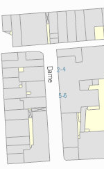
From a modern map you can see by scale just see how slender it is. Barely noticeable:
The entrance from Dame Street is particularly narrow and is marked only by a beautiful mosaic on the pavement for the Stags Head pub. No doubt they placed it here as a marker for lost tourists and the like. It’s perfectly positioned, like an ‘X’ marking the spot on a treasure map, pointing you up this dark alley to find the shining light of the pub. There’s also a barbers sign, with no visible barber shop, which is also a nice touch. (See first image)

Magnificent Stags Head mosaic on Dame Street at entrance to alley
This is view looking down with your back to Dame Street:

(c) infomatique
Finally, this is the view up the lane with your back to Dame Court:

(c) infomatique

 Click on the book for more.
 Click on the book for more.

The 1848 map shows it uncovered from end to end, probably made it more visible from Dame St, whereas now, with the Mercantile jutting out over it, it’d be a lot easier to miss it completely only for the mosaic
Agree with you there Dr. Nightbus.
Great series on the laneways of Dublin. As a culchie living up here for a few years, I do like wandering and learning more about these!
Thanks for the feedback!
I suspect there is a parallel series on the “open spaces” of Dublin. I am thinking in particular of a set of institutions that seem to be spread in a band across North Dublin at about Griffith Avenue: St Patrick’s College, the school(s) for the Deaf, the school for the blind, Marino Institute of Education, the building that is now the Fire Brigade Training Centre, All Hallows, the (Roman Catholic) Archbishop’s Palace… . Some of them are no longer that “open” — for eaxmple, a large portion of Marino Institute has been turned over to apartments,
I haven’t checked it on the map, but my impression is that those institutions on the north side are more connected geographically than similar types of institutions on the south side. (Where did Protestant blind or deaf children get sent for an education?) I wonder if the north side institutions were built as land became accessible with road developments. And given the dominance of Roman Catholic institutions in the list, I wonder if there is a clear link to there development and Catholic Emancipation.
Good question.
Even in 1905, when Dillon Cosgrave’s ‘North Dublin, City and Environs’ was published, Drumcondra was barely urban: and more than a century before, when the house that is now the centrepiece of St. Pats and its counterpart in All Hallows were built, they were country residences – St Pats was owned by the same family whose town dwelling was Belvedere House – now the school of the same name.
These lands had been monastery lands – belonging to the Priory of All Hallows, where TCD now is – and were given to the Corpo after the reformation. Presumably, the Corporation then parceled them out to up and coming aristos in need of picturesque riverside estates. And then, in the 19th c, as such families deserted Dublin for London, the houses became vacant and the RCC, hungry for land and prestigious addresses took them over.
pity about the smell on this lane though, which generally makes it one to avoid.
Tomboktu, a lot of the institutions in north Dublin are there because of the historically much smaller amount of development north of the canals, compared to the more densely populated south side. The land that is now Marino Institute of Education and the Fire Brigade Training Centre was part of Lord Charlemont’s estate (he of the Casino Marino and Charlemont House), which was originally property of the Priory of All Hallows, as per sonofstan.
It’s been a while since I read it, but there’s a huge amount of detail about the development of Drumcondra and Marino in Ruth McManus’ book ‘Dublin 1910-40: Shaping the City and Suburbs’, where she talks about how the 19th century institutional land was developed into the inner suburbs. It was actually pretty uneven, with a working farm where Charlemont housing estate off Griffith Avenue is now up until the late 1980s, and another one at the corner of Collins Avenue and the Swords Road (where the Port Tunnel works were for a while), as well as lots of other spots of ‘rural’ land.
Back to Dame Court, wasn’t the Stag’s Head mosaic taken up and relaid at some point in the last ten or fifteen years? I have a distinct recollection of it originally being up against the mouth of the alley, but being relaid out to its present position.
That’s the first thing I thought when I saw the first photo! It was definitely at the alley entrance.
Ahhh yes! I do be rambling through it from time to time, a great short cut 🙂
AS kids we always knew that alley as ‘Bottleneck Lane’ on account of the shape of it….and as nippers we would deliberately go out of our way to use it whenever we were down that neck of the woods from Clanbrassil Street where I grew up. So street sign or no…..that has always been ‘Bottleneck Lane’ to my ilk….well ever since we learned to run around the city on our own in the 50’s.