The recent occupation of Moore Street brought to memory past struggles to save buildings and locations of historic interest in Dublin. The ghosts of Wood Quay and Fitzwilliam Street’s Georgian Mile sit on the minds of those involved in the campaign to save the terrace and rightly so; a blatant disregard for history and public interest has often been a feature of redevelopment in Dublin with countless significant sites permitted to intentionally fall into disrepair and dereliction and many more to disappear from our streetscape forever.
Mindful of this over the last couple of weeks, and in reading Frederick O’Dwyer’s excellent “Lost Dublin” I started to think about not only what we’ve lost architecturally and historically but what might have been in this city had history played out a little differently. We’ve already covered the rather ambitious original plans to build Hugh Lane Gallery across the Liffey and the stunning landscape of Abercrombie’s “Dublin of the Future” but what of other plans that for whatever reason fell by the wayside? Think the U2 Tower and the Liffey Cable Car but step back a few decades/ centuries…
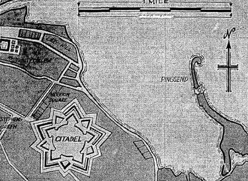
The Merrion Square Citadel, taken from The Irish Press
Prior to the construction of the North Wall, the East Wall and the Great South Wall, the Liffey meandered as it liked from source to sea. The construction of these walls and the reclamation of land they afforded, along with the construction of quay walls changed the landscape of Dublin to resemble much what we see today. 17th Century Dublin, as a result looked very different to the Dublin of today with the Liffey’s muddy banks allowed to find their natural course. Consequently, Merrion Square sat considerably closer to the banks of the Liffey than it does now, and in 1685 was the site for an audacious plan to replicate the Tilbury ‘Citadel’ Fort located on the Thames. The fort was originally planned in 1672 by ‘His Majesty’s Chief Engineer’ Sir Bernard de Gomme to sit closer to Ringsend, but on his death, a man named ‘Honest Tom’ Phillips proposed the location covering large parts of Merrion Square, Mount Street and Fitzwilliam Sqaure.
According to Frank Hopkins’ ‘Deadbeats, Dossers and Decent Skins’, “had it been built, the fort would have covered an area of thirty acres and would have been capable of accomodating seven hundred officers and soldiers.” The fort was to be brick built, faced with stone and encompass ramparts, ravelins, a curtain wall and overhanging bastions. The prohibitive cost of over £130, 000 along with a cessation of hostilities between the English and the Dutch caused the idea to be shelved.
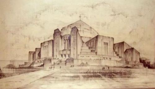
A 1934 drawing by L.F. Dowling showing the proposed Merrion Square Cathedral. From http://churcharchives.ie
Merrion Square was also the site for a proposed Cathedral in the nineteen thirties. As late as 1934 the then Archbishop Byrne is quoted as saying “Merrion Square has been acquired as a site for the Cathedral and on Merrion Square, please God, the Cathedral will be built.” The park had been purchased from the Pembroke Estate four years earlier for the sum of £100, 000. Of course the Cathedral was never built on the site and in 1974 the land was transferred to Dublin Corporation for use as a public park. The Pro Cathedral on Marlborough Street which had been altered and extended in preparation for the Eucharistic Congress remained the main Catholic cathedral in the city.
With the establishment of the Catholic University of Ireland in formality in 1854 came a need for a site for an actual physical University. On 20th June, 1862 a foundation stone was laid at Clonliffe, near Holy Cross College. The plans for what was to be known as St. Patrick’s University consisted of two large quadrangles, one consisting of the University and the other a residential block, Ruskinian in design and “not unlike some of the entries for the Whitehall Government Offices competition in 1857.” (Frederick O’Dwyer, Lost Dublin.) A contractor was employed but the project was shelved due to several constrictions on the site and in time a Catholic University would open on Dublin’s southside at Earlsfort Terrace- University College Dublin.
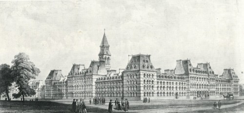
Drawing of the proposed Catholic University of Ireland, Clonliffe. From Frederick O’Dwyer’s ‘Lost Dublin’
The Loopline Bridge has always proved a controversial, but necessary feature in Dublin’s skyline. Built in 1891 with a view to improving the passage of British mail through Ireland, the main objection has always (mainly) been that the Bridge spoils the views of James Gandon’s Custom House. There were tentative plans in the early nineteen sixties for its removal altogether, alongside a major overhaul and re-configuration of Connolly Station with some platforms moving underground. The plans never bore fruit and the Bridge remains today, though largely without the advertising hordings that adorned it throughout the 20th Century.
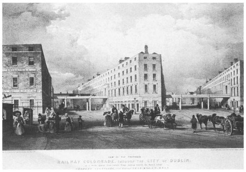
Long before the Loopline Bridge, and not without controversy either, there was the proposed Dublin Metropolitan Railway. In 1836, Charles Blacker Vignoles (the engineer responsible for Ireland’s first railway, the ‘Dublin and Kingstown’) proposed a rail line running between Westland Row and Watling Street to link with a projected line to the south of Ireland, from what would become known as Heuston Station. As can be seen in the image below, part of the projected line would run along the South Quays on a raised colonnade in a style Vignoles’ report called ‘Grecian Architecture of the Ionic Order.’
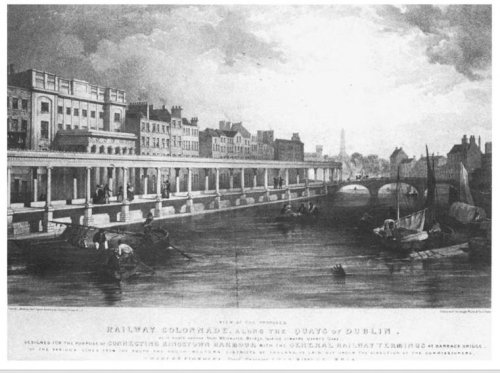
How the South Quays might have looked under the proposed Dublin Metropolitan Railway, from http://hugohickey.wix.com/archipeligo
The scheme called for bridges spanning D’Olier Street and Westmoreland Street going through tunnels in South Dublin’s buildings en route. The trains would “either be towed by horse or by ropes connected to stationary engines designed to ‘consume their own smoke.'” The report continued “the number of houses to be actually taken down or materially injured is only thirty seven and but few of these are of great value” and the works could “be rendered not unsightly, but rather ornamental.” The proposal was dismissed, but not dismissed completely by engineer Frederick Barry as he re-invigorated the idea in the early 1860’s alongside one to build a Central Train Station and hotel near Eustace Street.
Negotiations for his proposal were at an advanced stage and the Corporation went so far as to install a dummy bridge across Westmoreland Street purporting to show the effect a bridge would have on the area. A piece of timber is alleged to have fallen from the mockup and killed a female pedestrian. The Dublin Metropolitan Railway was doomed and the Bill, shortly to be laid in front of the House of Lords in Westminister summarily dismissed. A re-doubled effort from Barry proposing tunneled sections in a second Bill was also dismissed. (Frederick O’Dwyer, Lost Dublin)
The D’Olier Street and Westmoreland Street section of the proposed Dublin Metropolitan Railway. From http://hugohickey.wix.com/archipeligo
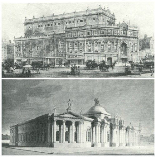
Two more projects that never saw the light of day. James Dillon’s 1884 design for 2,500 seater Lyceum Theatre (top) to be sited at the junction of Tara Street and Brunswick Street and Sir John Soane’s 1800 impression of a proposed Bank of Ireland headquarters on a site bounded by College Street, D’Olier Street and Westmoreland Street (bottom.) Both Frederick O’Dwyer, Lost Dublin
The Civic Offices at Wood Quay need little introduction. To call their development the biggest act of cultural vandalism the city and arguably the country has ever seen is to be restrained in one’s prose. In terms of archaeological importance, the viking site uncovered during the construction of the offices was priceless and practically unrivaled to anything found to date in Europe. “The remains were astonishing: complete foundations of wattle-and-daub houses; interior hearths and benches; workshops; timber pathways and boundary fences; and even latrines and rubbish pits filled with unique artifacts.” (History Ireland, Issue 2/ Volume 22)
What happened is a story every Irish person knows well. A petition that garnered two hundred thousand names and protest marches culminating in one twenty thousand strong were ignored and Sam Stephenson’s bunker like monstrosities stand on the site. Protests against development on the site went back as far as the fifties when the building below was proposed as the new headquarters of Dublin City Council. Designed in 1955 by Messrs. Jones and Kelly, its the disquiet regarding its construction was largely a worry the impact the building would have on one of the oldest parts of Dublin and the effect it would have on the Christchurch vista.
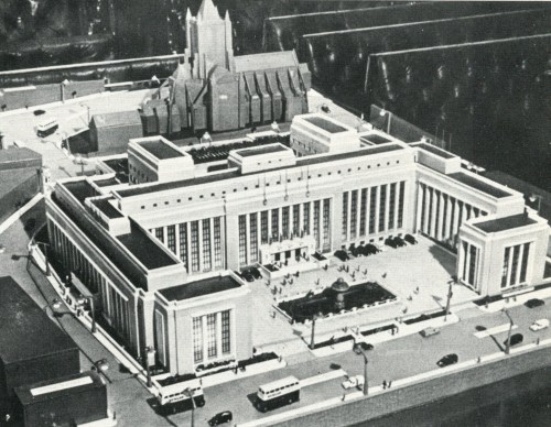
Model of the Jones and Kelly proposal for the City Council Offices at Wood Quay. From Frederick O’Dwyer’s ‘Lost Dublin’
The Liffey Quays could have looked very different as we’ve seen- from a railway running on a colonnade above them to museums being built across them. Nothing compares though, to a proposal to cover them in altogether. On Monday 13th June 1960 a proposal designed to alleviate the City’s traffic and parking chaos went in front of Dublin City Council from Cllr. Frank Sherwin which included plans to culvert part of the Liffey and roof it in from Grattan Bridge to Butt Bridge and in order to provide space for parking for a thousand cars. The proposal gained very little support with both the City Planning Officer and the City Engineer unsurprisingly coming out against it on the grounds of an increase danger of flooding and the sheer cost of the project which would cost more in itself than a multi story carpark. The Planning Officer “felt that the river was one of the dominant characteristics of the city and, as for a proposal to extend platforms from quay walls supported by piles, this, he said, would convert the river into a sort of a canal, with dark gloomy recesses, festooned with seaweed.” (press) Thankfully in this instance, some sanity of some sort prevailed.

 Click on the book for more.
 Click on the book for more.

An excellent well researched article, its fascinating to see what could have been inflicted, some good some bad, on Dublin and its Dubliners!
I do wonder will the proposed development for O’Connell St ever go ahead? Perhaps as soon as the Gubberment can steam roller over Moore St after it gets those politically embarrassing 1916 commemorations out of its way, after all we can’t have those poor developers left starving for too much longer! 🙂
Enjoy! http://www.skyscrapercity.com/showthread.php?t=1865474
[…] in January, we had a post on the blog dealing with the theme of ‘Dublin Re-Imagined’. It looked at some of the proposals for Dublin in decades and centuries gone by that fell by the […]